Hiển thị các bài đăng có nhãn Data Visualisation. Hiển thị tất cả bài đăng

Chủ Nhật, 3 tháng 8, 2008

Data Visualisation: Challenges in India


Image: Explorations to understand different types of data visualisations. Classification and Categorisation of data representation types using a bar chart metaphor.


The paper quoted below was prepared in response to an invitiaton from an Indian architectural magazine for commentaries on digital design and their impact in the classrooms at NID. This invitation gave us the opportunity to reflect and share the assignments and approaches that we had developed into a course for Information Design students at NID, first at the Paldi campus and later at the new campus at Gandhinagar for the students of New Media Design (NMD), Software User Interaction Design(SUID) and Information and Digital Design (IDD). Two of these disciplines do not exist now since the Institute has decided to relocate these courses to the newer campus in Bangalore and in the process the normanclature too has undergone a change. The new discipline is now called Information & Interface Design (IID). Bangalore campus also hosts two other disciplines since the last year called Design for Digital Experience (DDE) and Design for Retail Experience (DRE).

This course is discussed at a blog site that was set up by the teachers to be used by faculty and students and it is called Visible Information India. Just like the other blog that is used to document our courses in a contemporaneous manner, the Design Concepts and Concerns, this one too is used to report the class explorations as they happen during the semester. The course in Data Visualisation is inspired by the books and work of Edward Tufee and Richard Saul Wurman and it draws on the work of many web based initiatives that have followed the lead provided by these thought leaders.


Image: Classification and Categorisation of data representation types using a cityscape as metaphor.


Data Visualisation: Exploring Emerging Challenges and Opportinities in India
(Published in the architectural design magazine the “Indian Architect & Builder” in 2007.)

M P Ranjan & Rupesh Vyas
National Institute of Design
Ahmedabad

The Context and Intention
The area of visualization of data is growing in importance day by day. This phenomenon is impacted with the increasing use of networked data sources and a massive growth in the channels for communication available to all professions. This massive dissemination as well as the growth in bandwidth and increased computing resources being available at the user end terminals is driving growth for such visual representations of data for various useful purposes of planning and decision making. Here the demand for such representations is coming from both the print media and the broadcast media and strategies are ready to explode in the Internet applications as well. We can see the coming of age of the second-generation Internet products which will offered as a result of demand for such representations and due to their affordability. Keeping these emerging opportunities in mind a team of teachers at NID decided to develop and offer a course in Data Visualisation which could address these emerging needs and develop a framework for imparting the knowledge and skills needed to plan, conceive and execute such visual representations across many domains of application. These would include financial data, statistical data, demographic data, remote sensing data

The areas of application will eventually cover all fields of human activity from medical images to scientific data analysis tools and in financial markets that have to support exploding data streams that are difficult to keep track of using traditional modeling and analysis tools. The human mind and our sensory mechanisms are far too overloaded by the bombardment of these data streams that we are compelled to look for new and improved ways to “See the Data” rather than just look at numbers. While plenty of data is now available through real time systems from widespread automated monitoring, making sense of this data is becoming increasingly difficult due to human limitations of perception, cognition and response action.

The fields of application extend from playful ones in the area of game design as well as to life critical applications such a monitoring traffic flows in the sky and trend mapping in financial and medical situations, and the need to make sense of what we can now see and record with our available and emerging technologies. Geographic data from satellites, surveillance data from security cameras, medical data from pathology labs, home monitoring devices and investment needs of individuals through home banking all provide opportunities for new levels of visualization given the tools available to all of us. The media too has its needs for professional data managers and visualisers in mapping and modeling expressive action sequences to make current events both interesting and comprehensible to both experts and public alike. Decision makers will look for coherent presentations with visualisations of management and planning strategies and time-line models in new and complex business settings where an investment decision can make or break a company. Maps, charts, diagrams, models, statistical graphs, are all examples of visualization types that we are familiar with in today’s media and representation systems. We are entering a new area of dynamic data displays with advanced animation and representation systems that will make the reception and delivery of data several notches up the value chain and those who do it well will be at a premium position in the competitive market place of tomorrow.

This course was invented four years ago in response to these anticipated needs of the emerging marketplace and a number of experimental assignments were devised to bring both the students and the teachers up to date about the whole area of data visualization and its emerging opportunities. The course was divided into a series of interlocking and sequential assignments in a group and individual mode to make it truly inter-disciplinary and multi-disciplinary in approach and delivery. A few of the topics and assignments are described:


Image: Classification and Categorisation of data representation types using a matrix model.


Data Categorisation and Modeling
Data Categorization was the task that the whole group was plunged into from the very first day of engagement. The discussions on the taxonomy of data and data visualization were followed up by a quick assignment of collection of interesting and significant examples of data visualization from the various graphics and scientific books in the NID library. Student teams were encouraged to search and supplement images and diagrams, maps and models from Internet based sources as well. Each of the groups was to try and organize the total data collected into a meaningful structure through a process of classification that would follow intuitive categories that made sense to each group respectively. They could coin terms if required and if required leave an empty slot for a missing image type that they predicted or knew existed, but did not have a prototype in hand for the assignment. They were then expected to build a composite model of their classification showing the similarities and differences between that data types that they had discovered and in this assignment they were asked to assign attributes and categories apriori and through a process of brain-storming and debate, and not to follow any one authority to justify their choices and classification.


Image: Field and library research to visual model. Gandhi Ashram in Ahmedabad as a case study.


Image: Understanding dynamic data using visual representations and models. Mitakhali roundabout in Ahmedabad.


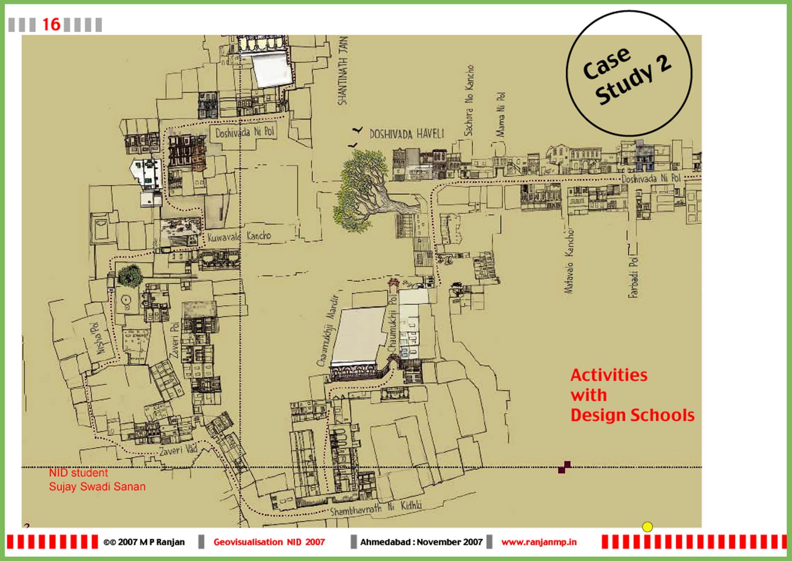
Data Capture: Field to Models
Representing live data from the field was the topic of the next exploration. The students were required to explore different contexts and to conduct field work and visit sites to start capturing data from the field using many techniques of observation and recording. Different milieus and the locations selected included, A shopping mall in Ahmedabad, the major traffic turnabout of six roads in Ahmedabad and the Sabarmati Gandhi Ashram for Tourists and International visitors. The models were developed to suit anticipated future needs as well as match the data captured in the field from observations and recordings.


Image: Modelling village aspirations and development opportunities for use by local population as well as planners. Village Sahpur study proposal.


Last year we gave our students the task if selecting three small villages near the Gandhinagar campus and they were to visit the village, meet the people and try and understand their needs, aspirations and resources through direct field contact. The idea was to give them an advanced assignment in data visualisation which was complex and wicked in its form as well as structure. Based on their field research the team was required to visualise the information that was generated in a collaborative mode in one image map that could be used by the local people as well as the village administration for development oriented activities.
 This is village Shahpur on the banks of the Sabarmati River near Gandhinagar in Gujarat. The village was one of three that the teachers selected by looking at Google Earth and the selection was made based on both proximity to our Gandhinagar campus.

This kind of design assignment gives us many insights that could be used to solve real issues of information management on a massive scale in India which has to deal with real needs of as many as 6,50,000 villages that dot our landscape and not just the cities that are taking up all our attention today. This project was done with the students and teachers using the inspiration offered by Christopher Alexander in his great thesis, "Notes on the Synthesis of Form."


Image: BusinessWeek data on Indo-China industrial competitiveness as reinterpreted by different students. Each used their own point of focus and through contextual research arrived at a unique representation in the process of sense making.


Dynamic Data Visualisation from Statistical sources:
Numerous sources of stastical data provide us an opportunity to explore visual representation across many fields such as sport, economics, weather, transportation, communication and others. Students were requested to use the UNESCO data that is available from their “Institute of Statistics” data centre at their website link and examine and analyse the data from one selected predefined table for a hypothetical decision or design action. Similarly a report from the BusinessWeek on economic parameters of industry in India and China was taken up as an individual task and here the same data was showcased in different styles and intentions by the students which revealed the possibility of variety in interpretation and representation in design. This is critical in design differentiation when competing agencies are showing the same data using different editorial policies which is the case in the real world.

About the authors:
Prof M P Ranjan and Rupesh Vyas are members of the faculty at National Institute of Design, Ahmedabad and Gandhinagar.

M.P. Ranjan
M. P. Ranjan is a senior member of the faculty of the National Institute of Design (NID), Ahmedabad, India and Chair of the Task Force on GeoVisualization set up by the Government of India. Ranjan is highly respected in the design community as a person who has unique insights about wide range of opportunities and responsibilities that lay before designers. He has deep knowledge of design applications in high tech sector, at the same time he has pursued projects to explore potential of bamboo, and other appropriate materials. Ranjan continually explores cultural, ethical, technological, and social issues that pose intellectual challenges for the design community.
web: www.ranjanmp.in
blog: www.design-for-india.blogspot.com

Rupesh Vyas
Rupesh Vyas has ten years of experience in Communication Design education and professional projects. Before joining NID he was teaching at Faculty of Visual Communication, M. S. University of Baroda. He is post graduate in Visualization from the same University.

He has contributed significantly to some of the major consultancy project having National importance. He is taking a lead role in developing Information and Digital Design as emerging discipline at NID. He has represented NID in different national and international forums like ICOGRADA, in Japan and in Expert Forum of traffic guiding systems by International Institute for Information Design (IIID), Vienna, Austria. 
He has special interest in developing innovative ways of information, interactions and interfaces in Public spaces, Location Based Information systems and Dynamic Data Visualization.
web: www.nid.edu

Thứ Ba, 18 tháng 12, 2007

WebInnovation2007: Web 2.0 Conference at Bangalore

A well-attended two-day conference at the Ashoka Grand in Bangalore with 750 professionals from the Information Technology sector included engineers, marketing executives and designers, all eager to understand and appreciate the various dimensions of the emerging Web 2.0 paradigm. Rupesh Vyas and I made a presentation that explored many opportunities for Web 2.0 applications that we see in India and in our presentation we focused on grassroots level explorations that had been initiated in our classroom projects at the NID and those that could be taken forward with real impact to a huge user base across India. The presentation titled “User Driven Web 2.0: Design Opportunities for India” defined design as we now understand it, an activity where human intentions mediated with thoughts and actions are used to produce value, great value.

Image: Study of Sahpur is offered as an opportunity for the use of Web 2.0 approaches to connect villagers in the Indian sub-continent to map local resources and aspirations for development initiatives across India.
The whole morning session was dominated by discussions on how the business sectors dealing with Web 2.0 could indeed generate revenue streams. It almost seemed that the speakers and the audience were obsessed with how anyone could create community and use this to create a monetized value for himself or herself. Little discussion on what could be done but much on how and how much, very disheartening indeed. The keynotes too kept returning to the concept of making money and the difficulty faced by web based companies in retaining their hard earned leadership in a highly competitive space. Perhaps the industry should try and focus on what can be done in India at the grassroots where it is needed the most and the value generated would create wealth for all of us across the country.

Image: Project INFARM done in 1995 as part of the Apple Design initiative is offered as an example of farmers as users of rich Web 2.0 applications in India.
In my presentation I talked of the Web 2.0 as being a new mind-set rather than a new technology, although many new technological as well as business processes can be listed as part of this new and emerging paradigm. However at the core it is for me about people working together on a spirit of sharing and this has less to do with many of the concerns of the industrial economy and even he knowledge economy as we have come to understand it today. We need a new attitude to understand the offerings that are springing up all around us in the form and shape of the Web 2.0 economy, or should we use another term to describe this phenomenon that is perplexing all of us who are trying to make sense of the emerging paradigm.

Image: The Heritage Walk in Ahmedabad as a opportunity for creative mapping of our cities by students using GeoVisualisation tools to create citizen generated content and rich local knowledge sharing that can create value for tourists as well as visitors to the city.
Thinking about the evolution of human ideas while sitting in the conference it did cross my mind that we have evolved from the hunter gatherer era when fire and tools gave humans an edge over other species on our planet. The settled agriculture era saw the rise of land holding as our currency and measure of wealth and this also spawned the zamindari attitudes and created the nobles and commoners. The smokestack industries were built on mined minerals and energy from fossil fuels. Land, minerals and finance formed the backbone of the economy till this was disrupted by the hi-tech industries that used knowledge and technology as the prime drivers of the economy. The emergence of the web and the internet opened a new space for creative disruption and the brick and mortar establishments had to give way to the dematerialized economy where finance flowed through electronic networks and crossed national borders at will. We have now arrived at another disruption and suddenly concentration of wealth of the previous eras is being challenged by individual content creators and a new paradigm is needed to explain the open source characteristics of Web 2.0 and I think that we will need a new mind set to understand what this has in store for all of us. Surely creative sharing will be the driver of the web 2.0 era that is almost on us as we blog and share and build new applications that can accommodate all of us and our needs like never before.

Image: Handmade in India as a database that could bring Indian craftsmen on to a Web 2.0 platform as part of the creative economy of the future.
The four case examples that we used in our presentation called for design action starting from a deep study of user needs and aspirations and the users included villagers, farmers, students and craftsmen across India, who are all unusual subjects for a Web 2.0 initiative. However we believe that it is do-able if we can put together multi-disciplinary teams that can work closely with each user group and help build prototypes and concepts that can be refined and delivered in each of the sectors in which action is required. These cases are only indicative of what kinds of opportunities that we see in India and the scale of what is possible is indeed staggering. The details of the WebInnovation2007 Conference is available at this web link above and our presentation titled User Driven Web 2.0: Design Opportunities for India is a PDF file which can be downloaded from this link as a 2.2 mb file. The abstract of the presentation is quoted below.

Abstract of Paper and Visual presentation to the Web Innovation Conference, Bangalore in December 2007

User Driven Web 2.0: Design Opportunities for India

Prof. M P Ranjan
Chairman, Geovisualisation Task Group, DST, Govt. of India
Faculty of Design
National Institute of Design

Rupesh Vyas
Faculty of Design
Coordinator Information Design Discipline
National Institute of Design

India lives in many centuries and the rapid strides of development are impacting the lives of all of us particularly those who live and work in the rural sectors of our economy. It is here that most of our people live and perhaps where we should be making an effort to impact through a concerted impetus of design to make to make the tools and processes accessible to the people who need it the most.

How do we achieve this when the tools and technology have been held and operated by educated and urban oriented individuals and institutions for all these years? This is perhaps where design imagination and technological commitment can create new avenues for the application of these innovative tools and techniques in a democratic and ubiquitous manner all over our land. Is this a just in theory and like a distant dream or can or become a reality? Can we demonstrate this possibility in a few significant case studies so that it evokes a sense of commitment across the country to use these now widely available resources particularly in an IT enabled manner?

Can the emerging understanding of what is Web 2.0 create a platform of collaborators across disciplines to achieve what many institutions and Governments cannot do on their own? We believe that the time is right to take the technologies to the people and that we operate it in a bottom up approach with imagination and commitment to achieve what needs to be done. Do we know what is needed? Perhaps even here we will once again go to the bottom of the value chain and use the tools of co-creation to work our way back to new and exciting offerings that can transform our national, regional and local economies, one step at a time.

In this paper we will show that many new applications are indeed possible and these would cover the hitherto ignored areas of application in a participatory manner. This should make it both usable and relevant to the local conditions and meet the aspirations of the people whom it is to serve. Some suggestions have been made using examples of classroom and research projects conducted by the students and faculty of the National Institute of Design to show how these tools and knowledge domains in the area of Web based communication and exchange can be applied to new and interesting applications. This would establish that we can reach far into our rural hinterland and show that these could become a mission that would be achieved through active user participation to address local needs and aspirations in a variety of critical areas of application.

These could be called design opportunities since the intention is to add value to the local situation through making the information and knowledge both usable as well as accessible to the users in their own domains is a starting point for the design journey. With partners from technology and the user base much can be achieved which was hitherto not attempted. This is an invitation to imagination of what could be and not what is; do join us in this journey.

Thứ Sáu, 30 tháng 11, 2007

User Centric Design Opportunities for GeoVisualisation

Paper and Visual presentation to the first National Conference on GeoVisualisation (GVDRP-2007) at NID in December 2007.
Image: Case Study on village resource mapping assignment by the students of Gandhinagar Campus of NID.

User Centric Design Opportunities for GeoVisualisation: A presentation to the first Geovisualisation Conference at NID.

Prof. M P Ranjan
Chairman, GeoVisualisation Task Group, DST
Faculty of Design, National Institute of Design, Ahmedabad

Abstract
The first National Conference on GeoVisualisation (GVDRP-2007) gives us a unique opportunity to reflect on the design opportunities that are emerging in our country for the creation of User Centric Design in the field of GeoVisualisation. Design can bring a new approach to the use of the amazing technologies that have been developed by science and technology and this is an area that we will need to focus on if the current developments are to be put to effective use by ordinary people in their day to day lives.

India lives in many centuries and the rapid strides of development and the forces of globalisation are impacting the lives of all of us, particularly those who live and work in the rural sectors of our economy. It is here that most of our people live and perhaps where we should be making an effort to make a positive impact through a concerted effort to make the tools and processes accessible to the people who need it the most. How do we achieve this when the tools and technology has been held and operated by educated and urban oriented individuals and institutions and when these are not designed to be available to the rural inhabitants? This is perhaps where design imagination can create new avenues for the application of these new tools and techniques in a democratic and ubiquitous manner all over our land. Is this a pipe dream or can or be a reality? Can we demonstrate this possibility in a few significant case studies so that it evokes a sense of commitment across the country to use these now widely available resources particularly in an IT enabled manner.

Image: Case Study of a student project by Sujay Swadi Sanan made by hand drawn buildings to illustrate the Heritage Walk Map for the Old City of Ahmedabad. In this paper we will show that many new applications are indeed possible and these would cover the hitherto ignored areas of application in a participatory manner to make it both usable and relevant to the local condition and the aspirations of the people whom it is to serve. Some suggestions have been made using examples of classroom and research projects conducted by the students and faculty of the National Institute of Design to show how the tools and knowledge domains in the area of geovisualisation can be applied to new and interesting applications that can reach far into our rural hinterland and how these could become a mission that would be achieved through active user participation to address local needs and aspirations in a variety of critical areas of application. These could be called design opportunities since the intention is to add value to the local situation through making the information and knowledge both usable as well as accessible to the users in their own domains.

The areas of application that we see are in mapping out the resources and local knowledge resources in a highly usable geospatial data base that is empowered and enabled by local participation and with the close involvement of local school and professional participants. For this to work we would need a back end that is technology enabled and based on web based tools as well as a field level strategy to keep the database alive and locally relevant. The fields of application could be for stakeholders in primary and secondary education as well as to empower the enormous skill base that promises to become the foundation of the creative economy of the future just as it has been an active ingredient in the sustenance of the rural economy in the past. Blending the past and the future to meet emerging needs could give us immediate benefits as well as long term resources to move our economy forward with wide participation of many sectors of our population. The areas that we envisage are village resource mapping that could be carried out and maintained by the use of simple and usable technologies in conjunction with sophisticated but highly usable backend technology tools and infrastructure. Such maps would keep local data of interest to local stakeholders as an area of priority and the creation and utilization could be carried out in a decentralized manner while remaining usable for a host of administrative and developmental situations.

Image: Case Study of the proposed web enabled and geo-referernced database of handicrafts clusters in India that could be used to empower and enable the creation of creative industries based on a rich local resource of skills and tarditional knowledge. The examples that are shared include a heritage walk at Ahmedabad, a village resource and design opportunity mapping venture, a craft skill and distribution mapping research as well as some speculative applicatioins that are proposed to be taken up with design students at NID in the near future. These design driven applications and explorations will be local in character but some of the insights that are gleaned would help set the agenda for a wider mission based application that would bring huge benefits to the stakeholders across the country. It is proposed that the DST and the NID Centre for Geovisualisation could partner in the research that is needed to make these design journeys that will set the tone for new and effective applications of Geovisualisation in the country.

The visual presentation titled "User Centric Design Opportunities for GeoVisualisation" can be downloaded from here as a 1.9 MB pdf file.

Conference on Geovisualisation at NID: Concluding Remarks by Prof. M P Ranjan


Image: Detail of a map of the Heritage Walk through the Walled City of Ahmedabad designed by NID student Sujay Swadi Sanan in the classroom. He used hand drawn facades of each building along the route showing a unique and creative expression of Geospatial Data that can be used by tourists and heritage enthusiasts.

Concluding Remarks to the 1st National Conference on GeoVisualisation held at the National Institute of Design, Ahmedabad on 28th to 30th November 2007. This was co-sponsored by The NRDMS (DST) Government of India, New Delhi and the NID, Ahmedbad.

M P Ranjan
Chairman, Geovisualisation Task Group
and
Faculty of Design, National Institute of Design

As the Chairman of the Task Group on Geovisualisation it is my task to use this occasion to make my concluding remarks that would help delineate the agenda of the task Group as well as list the areas of focus the we would need to focus on in the days ahead particularly in the context of the deliberations and recommendations that have come out of this wonderful conference. On behalf of the Task Group on Geovisualisation I would list the core areas of emphasis that would help us set priorities and directions for the work in the field of Geovisualisation in the Indian context in the days ahead.

1. The first Conference on Geovisualisation has helped us bring together a large number of expert groups at a design institute who have a great deal of cumulative experience in the subject and we are grateful to the speakers and participants for sharing their insights that have culminated in the drafting of the recommendations that would be reviewed by the NRDMS DST, Government of India to take this initiative forward.

2. We have a good list of proposed Demonstration Projects and domain specific initiatives that is an outcome of this conference as well as the ongoing activities of the Task Group in identifying and initiating these through the expert groups who can carry out the research required to deliver these demo projects and then help realize in on the ground where it is needed.

3. The proposed Centre for Geovisualisation at NID has taken a step forward with the NID team putting together the first Conference on Geovisualisation and this event has given us the opportunity to review the scope and dimensions of the field and this will help set the plans for the research and education activities of this Centre in the days ahead. The infrastructure and skill sets that would be brought to this Centre too would be informed by the ongoing discussions with the various expert groups that the NID has been able to bring together under a common platform of this Conference and in the days ahead I am sure that these small steps will be supplemented by a sustained programme of research and design action that will give a strong impetus for the field as a whole particularly since one of the key roles will be the challenges that come with the field being multi-disciplinary and therefore having many implications of the integration of a diverse set of skills and knowledge into usable and high quality offerings in the field of GeoVisualisation.

4. Promotion of the concepts of Geovisualisation and the need for the use of Geo-Spatial data bases in a effective manner with the help of Geovisualisation tools and procedures needs to be embedded in many sectors of our stakeholder groups and in this initiative it is recognized that we will need to make a sustained effort to reach out to all the stakeholders be they young students who need to understand the concepts or to decision makers who would need to use these tools and concepts for the various fields of application that have been discussed in this Conference.

5. The promotion activity would need to extend to the Policy makers at the National as well as the Regional levels and to a large number of our administrators who would be sensitized to the future possibilities and critical features of the Geovisualisation activity space. We would also be working on the area of Policy guidelines that can enhance and extend the use of this knowledge and skill through the drafting and processing of supportive policy frameworks so that much of the data that is held in the Government sector can be mobilized for development initiatives in the local Panchayati Raj Institutions across the country in a decentralized manner.

6. We need a good Communication Platform in order to achieve the reach and impact of a rapidly growing field as well as the locate India at the leadership position that it had in the field of Cartography and public data use for good governance. We propose to set up an Web Portal that uses Web 2.0 standards to empower rapid and sustained participation of a large number of players as well as support cooperation across domains and institutional boundaries in an open source framework to make the whole initiative cost effective and accessible to all sections of our society.

7. The whole area of Training, Content Generation and Demonstration through the identification and creation of suitable exemplars has assumed a major significance in the task of the Geovisualisation Task Group. The expert groups are requested to address this urgent requirement and create fertile experiments and elective based offerings in existing institutes and university departments to fast track the development of these critical resources which can then be offered through a mass contact programme as e-learning initiatives to the numerous stakeholders that would need to be reached by these training initiatives in the days ahead.

8. The Task Group on Geovisualisation would also flag the Key Policy Issues that would need the attention of Government and try and articulate the areas of priority and the desirable directions that would need to be taken in this composite field that is now called by the broad term of Geovisualisation. One of the key recommendations that have been stressed by a number of speakers is the use of Government funding and policy and legislative supports to make these inputs an Avenue for the Open Source movement to grow in India in such a manner as to ensure easy access to such resources at the grassroots level all over the country.

9. The Task Group on Geovisualisation is also determined to Expand the Base of Experts and Partners who can contribute to the Geovisualisation movement taking root in India and here in addition to technology, science and design we will need to bring on board management and administration at many levels so that a seamless transfer of research to the land can take place through the creation of useable products and strategies in all fields of application.

I compliment the NID and NRDMS-DST teams for the excellent conduct and planning of this Conference on Geovisualisation and we do look forward to a sustained programme of activities in the days ahead. I would like to thank the National Institute of Design and its Director, Dean of Gandhinagar Campus and the Anchor Faculty from NID for being excellent hosts and for the three days of stimulating discussions and presentations that have brought a good number of insights that can be taken forward by the Task Group on Geovisualisation with the active support of the NRDMS-DST Government of India.

Contact Information for Proceedings and Resources
For obtaining copies of the proceedings and any additional information the contact person is Dr Bibhu Dutta Baral, Chief Coordinator & Anchor Faculty: Geovisualisation Research Initiatives at NID
email contact:

Thứ Năm, 29 tháng 11, 2007

First National Conference on Geovisualisation: Welcome Address by Prof. M P Ranjan

Image: Screenshot of village study done by NID students as part of the Data Visualisation course to explore applications for geovisualisationWelcome Address delivered to the 1st National Conference on GeoVisualisation held at the National Institute of Design, Ahmedabad on 28th to 30th November 2007. This was co-sponsored by The NRDMS (DST) Government of India, New Delhi and the NID, Ahmedbad.

Prof. M P Ranjan
Chairman, Geovisualisation Task Group
and
Faculty of Design, National Institute of Design

Welcome to NID and this is a good time to raise some questions as well as to try and provide some answers.

I have four key questions and a host of associated answers. So let me begin with my Welcome address by addressing these one by one.

1. Why GeoVisualisation? What is it anyway?
What are the Issues and opportunities? What are the domains of application? In my personal agenda is another big question, which is, how do we make complex data dealing with geographic spatial implications visible and usable to the ordinary citizen in India.

We stand on a great tradition of cartography in India. A few years ago NID was requested by the Department of Science and Technology, Government of India to work with the Office of the Survey of India to develop an exhibition to celebrate the Great Arc project which was the first ever mapping of a part of the globe and this had happened in India some 200 years ago. Since then India has been at the forefront of cartographic traditions and now it is time to take leadership again through excellence in Geovisualisation. In this we would be happy to partner with the NRDMS-DST who have sponsored this event as well as reflect on the work done in Ahmedabad by ISRO and many other organizations that has set a platform for this new field of Geovisualisation to take root in India with a strong partnership between Design and science and technology initiatives.

2. Why Design?
Design is now being defined as a much broader field that takes intentions to the creation of value to society and ecology through a process of thoughts and actions. Design deals with products and applications and it has a user focus while the dominant ideology is having a technology focus especially in the fields of application that we are dealing with in the areas of geovisualisation.
Through design we intend to address the needs of many sectors including education, development, planning, management and most critical of all in the induction of innovation into this sector and all the potential applications so that we can unfold huge value in the process of both creation as well as delivery.

3. Why this Conference?
The geovisualisation agenda can only be addressed by adopting a multi-disciplinary context as a given condition for moving forward since so many disparate skill sets would need to be integrated and this is an attempt to bring all these skill sets to a common platform to address our complex needs and opportunities. This is also an attempt to bring together the multiple knowledge domains of geography, cartography, computation, visualization and design in the service of real challenges that call for the use of geospatial data and representation for the core tasks of local planning as well as in decision support systems in a number of domains of application. We also need to build awareness, commitment and the linkages that are necessary to make the whole operation to be useful to the people at large in many parts of the country as well as in many walks of life and at many levels, local and national.

4. Why at NID?
The Institutional objectives of NID has taken us down a path of discovery and in recent years NID has set up a number of new initiatives that deal with technology design fusion that has culminated in the setting up of new programmes and disciplines and the setting up of two new campuses in Gandhinagar and at Bangalore. Both these initiatives are to supplement the work that has been done over the years at the Paldi campus dealing with promoting design as a core ability in a huge number of sectors of our economy, in my estimate, about 230 sectors that are in critical need of that discipline. NID has proposed the setting up of a Centre for Geovisualisation to provide a platform for research and design explorations in the various sectors of application of geovisualisation which would need a strong interface with the already developed areas of science and technology with particular emphasis in making these applications user friendly by addressing opportunities in usability and accessibility by those who need it the most. We hope to use this conference to help build the agenda for research and education to be conducted by the proposed centre and I would call on the participants to provide directions and suggestions for the NID team to take forward in the days ahead. We are also interested in showing through our interest and actions that the various investments in science, technology and management need to be supplemented by investments and the use of design in this very critical new field and that this would influence other such initiatives for partnership across disciplines in the days ahead.

Welcome to NID and to Ahmedabad. I would, like to take this opportunity to welcome all the speakers and delegates, students and experts to NID as well as to compliment the NID and DST teams that have done the background work to make this happen. I would particularly mention Dr Bibuda Baral and Rupesh Vyas of NID and Dr D Dutta of NRDMS, DST, Government of India and to their teams for their sustained efforts to help realize this event. I would also take this opportunity to thank the Geovisualisation Task Force team as the Chairman of the Committee for their active support in leading the deliberations that have culminated in the launch of the first National Conference on Geovisualisation and for setting in motion a chain of events that will be of huge significance in the years ahead. I will be speaking later on the theme of usability and in my presentation I will share my views on areas of application and on the design opportunities that I see for the read ahead in the field of Geovisualisation in India.

Thứ Tư, 1 tháng 8, 2007

Visible Information India: A new blog on Data Visualisation


Data Visualisation and Information modelling is emerging as an important field of design action and in the age of media and computer based interaction the opportunity to make data visible is both an art as well as a science that needs to be used in all walks of life as well as in the core offerings from business and governments alike. This blog called "Visible Information India" is therefore a platform that will be used by students in the Data Visualisation class at the National Institute of Design in Ahmedabad and Gandhinagar to share and showcase their ongoing efforts with their teachers as well as with others interested in taking this new activity to a higher level of professionalism. This course was created three years ago with the first batch of students from the new digital design disciplines at NID and it has been found useful for other groups as well as by the industry representatives who had come for the placement activity at the end of these programmes. This year, the two week course is conducted by Prof. M P Ranjan and Rupesh Vyas at the Gandhinagar campus for students of the Information and Digital Design discipline (IDD). The first assignment given to the students is the analysis of modelling data flows on the Google Analytics service as they are applied to the design of institutional and personal websites and we hope to see this work documented and shared in near real time during the conduct of this course at NID.
"Visible Information India" blog on Data Visualisation


Experimental assignment done last year on mapping village resources for use by local people in a village near Gandhinagar.

Through this platform of, "Visible Information India" blog, the faculty will also share their insights and comments on the emerging field as well as post book reviews and discussions on current developments that may be pertinent to the subject at hand, making critical and useful information visible for and in India. This resource will cover design approaches for the creation of maps, models and diagrams as well as dynamic data representations of a number of domains such as financial, medical and decision support, to mention only a few.