I love this site: http://earthdata.nasa.gov/data/near-real-time-data/rapid-response/modis-subsets
From there, I can keep an eye on fun things like ice-out & freeze up, monitor forest fires, check snow cover, and more. All with images that are as little as a couple of hours old.
To find the images relevant for my area (central Saskatchewan), I choose the North America subset, then roll my mouse over the images to find the ones I want, usually "Waskesiu" (covers from Lake Diefenbaker in the south to north of the Churchill River, and extending well into Manitoba to the east and Alberta to the west) or "Bratts Lake" if I'm interested in areas to the south, or "Thompson" if I'm interested in areas to the north.
From there you can choose the resolution you want, and the type of image you want. They offer several types of images which are probably very meaningful to those that know how to interpret them, but I normally stick to the True Colour images. You can also turn on layers to show fires, borders, and coasts. This is helpful to position the image with points of reference you are familiar with. You can also download the image into Google Earth which makes pinpointing less-obvious locations very easy.
Due to those pesky clouds, you may not be able to see a given area on the specific date, but you can scroll through the days to find a nice clear view.
For those who paddle the far north, this is a great way to keep an eye on whether your float plane will be able to land or not. For the rest of us, it's fun to check it out and dream of trips.
The image from yesterday, a warm day with lots of cumulonimbus, is shown below (head to the website for much better resolution, but don't expect to be able to peer into anyone's back yard).
Less than hour after I posted the above, I find another way to view the same thing, and it's pretty awesome: http://earthdata.nasa.gov/labs/worldview/
Hiển thị các bài đăng có nhãn Weather. Hiển thị tất cả bài đăng
Thứ Tư, 15 tháng 5, 2013
Thứ Sáu, 3 tháng 5, 2013
Codette Lake Ice Surge
This was filmed by the Saskatchewan Water Security Agency (formerly Sask Watershed Authority) on Codette Lake, about 250 km northeast of here. Unbelievable.
Thứ Năm, 25 tháng 4, 2013
Strange Micro-Climate Around Fort Mac?
I was having a look at satellite photos to check on the snow melt in the prairies and wondering if the Saskatchewan Rivers were opening up. Indeed, the North Saskatchewan River seems to be opening up. All of the prairies are covered in snow with the exception of southern Alberta and southwestern Saskatchewan. Then I noticed a peculiar dark patch surrounding Fort McMurray. It seems that this one spot in northern Alberta has also had it's snow melted, or the snow is dark in colour. It just happens that the area closely corresponds to the bitumen sands (aka tar sands) and the oil processing facilities there. Go figure.
The image above is a cropped view of the satellite image (find the original at http://lance-modis.eosdis.nasa.gov/imagery/subsets/?subset=AERONET_Fort_McMurray.2013114.terra.250m) from yesterday viewed via Google Earth. The river heading south to north is the Athabasca River and the Clearwater River joins at Fort McMurray flowing west out of Saskatchewan. The brown area amounts to about 90 km north and south, and about 35 km east and west.
By the way, the above effect is not simply due to urbanization. The larger cities of Edmonton & Saskatoon look much more white than the area around Fort Mac.
| Daily satellite image from 24/04/2013 viewed as a Google Earth overlay. The dark region is in stark contrast to the white of the remainder of northern Alberta and Saskatchewan. |
By the way, the above effect is not simply due to urbanization. The larger cities of Edmonton & Saskatoon look much more white than the area around Fort Mac.
Thứ Tư, 12 tháng 9, 2012
Weather: Frontal Analysis & More
Maybe it's the farm background, maybe it's biking to work each day, but I try to pay attention to the weather. I like trying to figure it out (though I usually can't), and I like looking at what's going on. Here's another tool in my quiver that I learned about this week from "nootka" on the West Coast Paddler forums.
You can find a variety of information at http://weather.unisys.com and it's pretty neat stuff.
This shows the fronts, where they are currently, and where they were for the past 12 hours.The image below should show the current fonts. (Or go to http://weather.unisys.com/surface/sfc_fronts.php?inv=0&t=cur to see it on the Unisys website.)
Of course when you look at this it will all be different, but currently there is a giant cold front that has been sweeping across North America for a few days now. Yesterday, it brought very high winds to the prairies (it's still windy today, but not quite so bad) that blew my father and brother's crops away, very literally. It's amazing how quickly a good crop can go from good to nearly gone in a few hours.
Here's another map that shows the surface data: http://weather.unisys.com/surface/sfc_map.php?inv=0&t=cur®ion=wc - by going to the link you can select your region, the type of map, & the information it shows.
There is a fair bit more at the website to explore and I've only just started poking around the http://weather.unisys.com website.
You can find a variety of information at http://weather.unisys.com and it's pretty neat stuff.
This shows the fronts, where they are currently, and where they were for the past 12 hours.The image below should show the current fonts. (Or go to http://weather.unisys.com/surface/sfc_fronts.php?inv=0&t=cur to see it on the Unisys website.)
| Current frontal positions in North America. Image source comes from http://weather.unisys.com/surface/sfc_fronts.php?inv=0&t=cur. |
Here's another map that shows the surface data: http://weather.unisys.com/surface/sfc_map.php?inv=0&t=cur®ion=wc - by going to the link you can select your region, the type of map, & the information it shows.
| Surface data with Canada selected as the region. Image comes from http://weather.unisys.com/surface/sfc_map.php?inv=0&t=cur®ion=wc. |
Thứ Tư, 13 tháng 1, 2010
Forecast For A Winter Trek
I'm heading with a group for an overnight snowshoe and camping trip to Prince Albert National Park this weekend. The forecast is for pretty mild weather, but we're still a few days out so there's room for change. Let's have a look at what the two main forecasters are predicting for the area for the weekend. I'll revisit this next week, after we come back.
I've taken screenshots from the website of both forecasters (just after 5 pm), cropped and rearranged them a bit, and posted them here.
First, the forecast provided at www.weathernetwork.com:
And now, the same from Environment Canada at www.weatheroffice.gc.ca:
So that's the forecast, lets see what reality brings....
Google Account Video Purchases
Prince Albert National Park, SK, Canada
Thứ Năm, 12 tháng 6, 2008
Paddling Forecast?
I want to pit Environment Canada (Weatheroffice) and Weathernetwork.com against each other and against reality to see who comes out on top. I am enrolled in a kayak course and this Saturday is the final session, to be held out at Pike Lake where we'll also be camping for the weekend. It would be great if it was nice and warm. That seems unlikely, but maybe we can hope for the rain to hold off? It seems lately that the forecast has been changing on a nearly hourly basis and that they really are having troubles getting it right. I also am no longer certain that what was the Canadian standard, Environment Canada, is any better than the competition, led by the Weathernetwork. Both of the forecasts below were downloaded at about 10:30 this morning.
Here is what Environment Canada is forecasting:
Here is what Weathernetwork forecasts:
So for Saturday when we're on the water, Environment Canada says we will have "A mix of sun and cloud with 40 percent chance of showers. Low 7. High 16." For the same day Weathernetwork's forecast is actually pretty similar though they increase the high to 18C and decrease the chance of rain to 20%. This is a lot more similar than these two forecasters have been in the past. I will follow up with this and post an update of how this forecast changes over the next day or so, and how things actually shape up.
12/6/08 - 9:05 pm Update: Environment Canada has modified it's forecast for tomorrow (Friday) and Saturday. For Friday's forecast they have reduced the chance of showers to 40%, and reduced the forecast high to 19C. Fairly small changes. However for Saturday, the chance of rain (40%) has been removed entirely and the forecast now is simply for "showers". Great.
13/6/08 - 10:20 am Update:
Environment Canada:
Update: 17/06/08 - The weekend was wet. Friday turned out pretty nice, but we got some rain in the evening. Saturday, the rain was periodic through the day and we were graced by a thunderstorm passing just to the north of us during our kayak lessons. In the evening it began to really rain and continued to do so for about 3 hours, ending about 10 pm. I think we had well over an inch of rain during the day. Unfortunately, due to the soggy conditions and the poorly graded tent site (we had the best spot in our camp site) we had water come up through the bottom of our tent and our sleeping bags got damp. The following is for the Saskatoon airport, about 50 km north of where we were. I'm just copying and pasting it in so excuse the imperfect formatting.
Here is what Environment Canada is forecasting:
Here is what Weathernetwork forecasts:
So for Saturday when we're on the water, Environment Canada says we will have "A mix of sun and cloud with 40 percent chance of showers. Low 7. High 16." For the same day Weathernetwork's forecast is actually pretty similar though they increase the high to 18C and decrease the chance of rain to 20%. This is a lot more similar than these two forecasters have been in the past. I will follow up with this and post an update of how this forecast changes over the next day or so, and how things actually shape up.12/6/08 - 9:05 pm Update: Environment Canada has modified it's forecast for tomorrow (Friday) and Saturday. For Friday's forecast they have reduced the chance of showers to 40%, and reduced the forecast high to 19C. Fairly small changes. However for Saturday, the chance of rain (40%) has been removed entirely and the forecast now is simply for "showers". Great.
13/6/08 - 10:20 am Update:
Environment Canada:
- Today - Day: Cloudy. 70 percent chance of showers. Wind northwest 20 km/h. High 18. UV index 4 or moderate.
- Night: Cloudy. Wind northwest 20 km/h becoming light this evening. Low 10.
- Saturday - Cloudy. 40 percent chance of showers in the morning and early in the afternoon. Wind becoming northwest 30 km/h late in the morning. High 18.
- Sunday - Sunny. Low 7. High 21.
- Monday - Sunny. Low 8. High 22.
- Tuesday - A mix of sun and cloud with 30 percent chance of showers. Low 11. High 25.
Update: 17/06/08 - The weekend was wet. Friday turned out pretty nice, but we got some rain in the evening. Saturday, the rain was periodic through the day and we were graced by a thunderstorm passing just to the north of us during our kayak lessons. In the evening it began to really rain and continued to do so for about 3 hours, ending about 10 pm. I think we had well over an inch of rain during the day. Unfortunately, due to the soggy conditions and the poorly graded tent site (we had the best spot in our camp site) we had water come up through the bottom of our tent and our sleeping bags got damp. The following is for the Saskatoon airport, about 50 km north of where we were. I'm just copying and pasting it in so excuse the imperfect formatting.
SASKATOON DIEFENBAKER INT'L A
SASKATCHEWAN
| Latitude: | 52° 10.200' N | Longitude: | 106° 43.200' W | Elevation: | 503.80 m |
|---|---|---|---|---|---|
| Climate ID: | 4057120 | WMO ID: | 71866 | TC ID: | YXE |
| Hourly Data Report for June 14, 2008 | ||||||||||
|---|---|---|---|---|---|---|---|---|---|---|
| T i m e | Temp °C | Dew Point Temp °C | Rel Hum % | Wind Dir 10's deg | Wind Spd km/h | Visibility km | Stn Press kPa | Hmdx | Wind Chill | Weather |
| 00:00 | 8.6 | 7.9 | 95 | 32 | 9 | 24.1 | 94.88 | Mostly Cloudy | ||
| 01:00 | 7.6 | 7.1 | 97 | 5 | 11 | 24.1 | 94.89 | Mostly Cloudy | ||
| 02:00 | 6.5 | 6.4 | 99 | 7 | 11 | 24.1 | 94.86 | Mainly Clear | ||
| 03:00 | 6.4 | 6.4 | 100 | 26 | 9 | 24.1 | 94.89 | Mostly Cloudy | ||
| 04:00 | 5.4 | 5.4 | 100 | 24 | 4 | 16.1 | 94.89 | Mostly Cloudy | ||
| 05:00 | 6.2 | 6.2 | 100 | 21 | 4 | 16.1 | 94.90 | Cloudy | ||
| 06:00 | 7.4 | 7.4 | 100 | 24 | 7 | 16.1 | 94.92 | Cloudy | ||
| 07:00 | 9.0 | 9.0 | 100 | 29 | 6 | 16.1 | 94.97 | Cloudy | ||
| 08:00 | 9.8 | 9.7 | 99 | 28 | 11 | 16.1 | 95.01 | Rain Showers | ||
| 09:00 | 10.8 | 9.7 | 93 | 30 | 9 | 16.1 | 95.01 | Rain Showers | ||
| 10:00 | 11.6 | 10.4 | 92 | 30 | 7 | 16.1 | 95.01 | Rain Showers | ||
| 11:00 | 13.2 | 9.9 | 80 | 30 | 9 | 24.1 | 94.98 | Mostly Cloudy | ||
| 12:00 | 14.6 | 9.6 | 72 | 34 | 9 | 24.1 | 94.98 | Mostly Cloudy | ||
| 13:00 | 18.3 | 9.9 | 58 | 32 | 17 | 24.1 | 94.97 | Cloudy | ||
| 14:00 | 18.4 | 9.9 | 58 | 31 | 19 | 24.1 | 94.96 | Mostly Cloudy | ||
| 15:00 | 19.4 | 9.1 | 51 | 31 | 17 | 24.1 | 94.94 | Mostly Cloudy | ||
| 16:00 | 16.1 | 10.3 | 68 | 32 | 26 | 24.1 | 94.98 | Rain Showers | ||
| 17:00 | 11.1 | 10.8 | 98 | 3 | 9 | 2.4 | 95.13 | Thunderstorms, Heavy Rain Showers, Fog | ||
| 18:00 | 10.9 | 10.9 | 100 | 30 | 7 | 2.4 | 95.16 | Moderate Rain, Fog | ||
| 19:00 | 11.1 | 11.1 | 100 | 0 | 24.1 | 95.18 | Rain | |||
| 20:00 | 11.4 | 11.4 | 100 | 31 | 6 | 12.9 | 95.24 | Rain | ||
| 21:00 | 11.2 | 11.2 | 100 | 30 | 4 | 9.7 | 95.29 | Rain | ||
| 22:00 | 11.1 | 11.1 | 100 | 23 | 4 | 16.1 | 95.37 | Cloudy | ||
| 23:00 | 10.7 | 10.7 | 100 | 8 | 17 | 24.1 | 95.42 | Cloudy | ||
Thứ Sáu, 18 tháng 5, 2007
Nice Weather for the Long Weekend
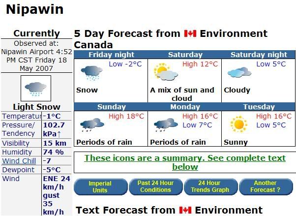
We're off to the Torch River again for three days of whitewater canoeing. "Whitewater" was intended to describe the frothy water through a rapids, not the frozen stuff falling from the sky! Actually, that forecast doesn't look half as bad as it did a few hours ago, even though rain figures more prominently than it did. 18C and some rain sounds pretty good!
Wish us luck!
Đăng ký:
Bài đăng (Atom)