 Image: Case Study on village resource mapping assignment by the students of Gandhinagar Campus of NID.
User Centric Design Opportunities for GeoVisualisation: A presentation to the first Geovisualisation Conference at NID.
Prof. M P Ranjan
Chairman, GeoVisualisation Task Group, DST
Faculty of Design, National Institute of Design, Ahmedabad
Abstract
The first National Conference on GeoVisualisation (GVDRP-2007) gives us a unique opportunity to reflect on the design opportunities that are emerging in our country for the creation of User Centric Design in the field of GeoVisualisation. Design can bring a new approach to the use of the amazing technologies that have been developed by science and technology and this is an area that we will need to focus on if the current developments are to be put to effective use by ordinary people in their day to day lives.
India lives in many centuries and the rapid strides of development and the forces of globalisation are impacting the lives of all of us, particularly those who live and work in the rural sectors of our economy. It is here that most of our people live and perhaps where we should be making an effort to make a positive impact through a concerted effort to make the tools and processes accessible to the people who need it the most. How do we achieve this when the tools and technology has been held and operated by educated and urban oriented individuals and institutions and when these are not designed to be available to the rural inhabitants? This is perhaps where design imagination can create new avenues for the application of these new tools and techniques in a democratic and ubiquitous manner all over our land. Is this a pipe dream or can or be a reality? Can we demonstrate this possibility in a few significant case studies so that it evokes a sense of commitment across the country to use these now widely available resources particularly in an IT enabled manner.
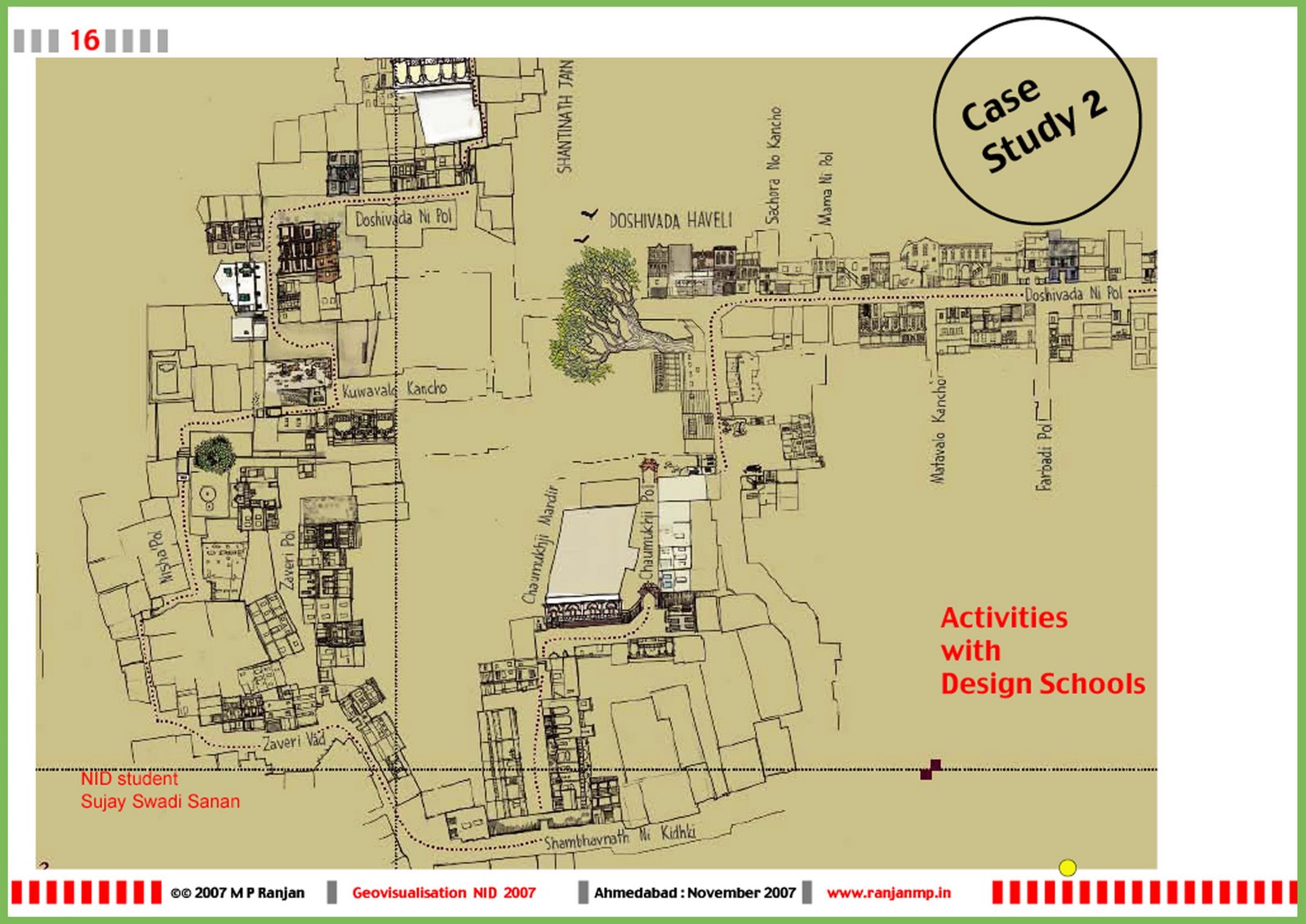 Image: Case Study of a student project by Sujay Swadi Sanan made by hand drawn buildings to illustrate the Heritage Walk Map for the Old City of Ahmedabad. In this paper we will show that many new applications are indeed possible and these would cover the hitherto ignored areas of application in a participatory manner to make it both usable and relevant to the local condition and the aspirations of the people whom it is to serve. Some suggestions have been made using examples of classroom and research projects conducted by the students and faculty of the National Institute of Design to show how the tools and knowledge domains in the area of geovisualisation can be applied to new and interesting applications that can reach far into our rural hinterland and how these could become a mission that would be achieved through active user participation to address local needs and aspirations in a variety of critical areas of application. These could be called design opportunities since the intention is to add value to the local situation through making the information and knowledge both usable as well as accessible to the users in their own domains.
The areas of application that we see are in mapping out the resources and local knowledge resources in a highly usable geospatial data base that is empowered and enabled by local participation and with the close involvement of local school and professional participants. For this to work we would need a back end that is technology enabled and based on web based tools as well as a field level strategy to keep the database alive and locally relevant. The fields of application could be for stakeholders in primary and secondary education as well as to empower the enormous skill base that promises to become the foundation of the creative economy of the future just as it has been an active ingredient in the sustenance of the rural economy in the past. Blending the past and the future to meet emerging needs could give us immediate benefits as well as long term resources to move our economy forward with wide participation of many sectors of our population. The areas that we envisage are village resource mapping that could be carried out and maintained by the use of simple and usable technologies in conjunction with sophisticated but highly usable backend technology tools and infrastructure. Such maps would keep local data of interest to local stakeholders as an area of priority and the creation and utilization could be carried out in a decentralized manner while remaining usable for a host of administrative and developmental situations.
 Image: Case Study of the proposed web enabled and geo-referernced database of handicrafts clusters in India that could be used to empower and enable the creation of creative industries based on a rich local resource of skills and tarditional knowledge. The examples that are shared include a heritage walk at Ahmedabad, a village resource and design opportunity mapping venture, a craft skill and distribution mapping research as well as some speculative applicatioins that are proposed to be taken up with design students at NID in the near future. These design driven applications and explorations will be local in character but some of the insights that are gleaned would help set the agenda for a wider mission based application that would bring huge benefits to the stakeholders across the country. It is proposed that the DST and the NID Centre for Geovisualisation could partner in the research that is needed to make these design journeys that will set the tone for new and effective applications of Geovisualisation in the country.
The visual presentation titled "User Centric Design Opportunities for GeoVisualisation" can be downloaded from here as a 1.9 MB pdf file.
